Wildlife management aims to develop long term conservation strategies to safeguard the wildlife populations to provide some general principles for reducing the impact on wildlife during operation in the proposed FMU and simultaneously promote awareness among the employees in logging camps and the local communities on the importance of wildlife conservation to the forest ecology.
Management Strategies and Recommendations
- Preservation of habitats and roaming grounds – For long-term measure, buffer zones or corridors of trees on both sides of the main, first and second order of streams and rivers system shall be established and reserved.
- Identification and management of protection and conservation of saltlicks – This is to allow animals, especially hoofed animals, such as Sambar deer, Barking deer and even monkeys to come and visit these “salt licks” for mineral supplement to their diet.
- Control of Hunting – By strict adherence of DF Circular No. 6/99 on wildlife conservator and improvement of gate control/guard house.
- Education and Preventive Measures – To instill awareness about wildlife management to forest workers.
Identification and Management of Protection Areas
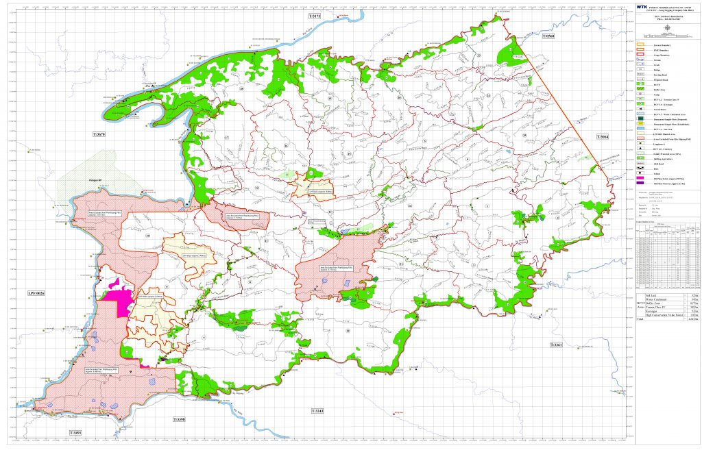
Protection areas were identified based on the need for conservation. There are 3 main fundamental for conservation will be identified such as conservation areas for protection of soil, rivers and wildlife.
The following criteria were used as reference for assessment:
- Non-commercial or poor timber stocking area for conservation of soil and flora and fauna.
- Site sensitive area.
- The presence/ absence of gazetted water catchment areas.
- Wildlife conservation area for example saltlicks, wallows and migration route.
- Community use area.
- Potential eco-tourism sites.
- Potential high conservation value forests.
- Sites of special cultural, ecological, economic or religious significance.
Management of Protected and Conservation Areas
| No. | Categories | Management Requirements |
| 1. | Non-Commercial or Poorly Stocked Area | Low stocking area will be excluded from the proposed FMU harvesting area. |
| 2. | Permanent Waterway | Riparian buffer zone as approved in EIA by NREB will be identified and demarcated with recommended width on the ground. |
| 3. | Steep Slope | Steep Terrain IV or slope greater than 35° as indicated in Sarawak Forest Map B will be mapped and excluded from harvesting within the proposed Pila – Mujong FMU. |
| 4. | Water Catchments | To identify on map and demarcated on ground for protection. |
| 5. | Boundary and Totally Protected Area | Buffer zone of 0.1 km width will be demarcated on ground for protection. |
| 6. | Critical Resource and Sites | Buffer zone of width 100 m surrounding identified critical resources and sites such as saltlick to be mapped and demarcated on ground. |
| 7. | Research Plot and Permanent Sample Plot (PSP) | PSP established by the FMU will be protected with at least 20 m buffer surrounding the plot perimeter boundary. |
| 8. | Community Use Area and Cultural or Religious Sites (if any) | Free, prior, informed and consent (FPIC) will be applied to community use area, cultural site and religious site and demarcated on ground for protection purposes. |
| 9. | Potential Tourism Area | Potential ecotourism and recreational sites would be identified and demarcated on ground (if any). |
| 10. | High Conservation Value Forest (HCVF) | To identify as protected area, to be marked on map and demarcated on ground |
High Conservation Value Areas Assessment Findings
HCV Assessment, likes EIA and SIA, involves the participation of the local communities. It is done by using the Malaysian Toolkit which was developed by WWF. HCV can be categorized into 6 categories as follows:
High Conservation Value(s)
| HCV | DEFINATION | HCV STATUS | Remark | |
| 2018 | 2019 | |||
| 1.0 | BIODIVERSITY VALUES | |||
| 1.1 | Protected area | Not present | Not present | |
| 1.2 | Threatened and endangered species | Present | Present | Rajah Brooke’s Birdwing (Trogonoptera brookiana) |
| 1.3 | Endemic species | Present | Present | 4 species Hornbills (Bucerotidae) recorded in Year 2019 & Year 2020 |
| 1.4 | Critical temporal use | Present | Present | 3 saltlicks (Apan) found in Coupes 5, 6 and 21 |
| 2.0 | LANDSCAPE LEVEL ECOSYSTEM | Present | Present | Terrain IV (slope > 35 °) |
| 3.0 | ECOSYSTEM AND HABITAT | Not present | Not Present | |
| 4.0 | ECOSYSTEM SERVICE | |||
| 4.1 | Water catchment | Present | Present | Water catchment found in Coupes 1, 4, 7, 14, 21, 22 and include exclusive area/gravity feed water supply. |
| 4.2 | Erosion control | Present | Present | Forest covers prevent erosion |
| 4.3 | Barriers to the destructive fire | Present | Present | Tropical Rainforest (Mixed Dipterocarp Forest) |
| 5.0 | COMMUNITY NEED | Present | Present | 127 Settlements (i.e. 83 (inside) and 44 (outside)) |
| 6.0 | CULTURAL VALUES | Potentially Present | Potentially Present | Burial grounds, scared/ritual sites (Tanah Mali) (24 burial grounds, 4 found inside excluded area, 10 were found inside the shifting agriculture. The remaining 10 were found adjacent or outside forest timber licence boundary) |
- There are 4 out of 6 HCVs as listed in the HCVF Malaysia Toolkit presence in the FMU.
- There are 35 fauna and 36 floras are identified as endangered, rare and threatened species found in the FMU (HCV 1.2).
- There are 18 endemic flora and 3 endemic fauna species (HCV 1.3).
- Areas for critical temporal use are identified (HCV 1.4).
- The FMU is located within the Pila – Mujong Working Plan area and it is a significant large landscape of forest to home different species of wildlife habitat in natural distribution. In a regional perspective, the main riverine reserves is served as wildlife reservoirs and corridors with adjacent FTL area within the Pila – Mujong Management Plan and is under part of the Kapit Stateland Forest and the Batang Baleh and Rajang Stateland Forest initiatives (HCV 2).
- Demarcation – Demarcate saltlicks 100 m x 100 m
- Maintain – Monitoring report twice a year
- Enhance – Consultation with WWF & FDS
- No history of forest fire was found within the FMU. Adjacent forest containing other HCVs is considered potentially present even though no records or data of HCVs were found during the assessment. HCVs information on surrounding areas may be available if adjacent FTL areas are conducting their HCVF assessment in the future. The FMU is only surrounded by FTL areas, there is some human settlement either inside or located within 1 – 3 km or identified affected communities (IAC) to the licensed boundary (HCV 4.3).
- No evidence of forest use by communities was found within the FMU area. Being remotely located near the Pelagus Forest Reserve Border and surrounded by FTL areas, there are some human settlements either inside community used area (i.e. SA area) or located within 1 – 3 km or identified affected communities (IAC) around the FMU boundary (HCV 5).
- No evidence and record of critical forest use from any community was found within the FMU (HCV 6).
Summaries of Management and Monitoring Recommendations for HCV
| HCV 1.1 – PROTECTED AREA | ||||
| No. | Management Recommendation | Action Taken | ||
| 1 | Demarcation of the buffer zone for forest nature boundary | A 100 m buffer zone along the forest nature boundary was marked in General Harvesting Plan (GP) and approved by Forest Department Sarawak (FDS). | ||
| 2 | Monitoring of perimeter of buffer belt to have identification on any encroachment. | Monitoring on all logging roads including the existing and old logging roads.Speed limitation of logging trucks and vehicles on the using of logging road to minimize the accidents in the proposed FMU. | ||
| HCV 1.2 – ENDANGERED, RARE AND THREATENED (ERT) SPECIES | ||||
| No. | Management Recommendation | Action Taken | ||
| 3 | Maintenance of the protection on protected species under forestry Rules. | All Endangered, Rare and Threatened (ERT) species listed in the Wildlife Protection Ordinance were not allowed to fell. | ||
| 4 | To carry out marking on the protected trees during reduced impact logging to prevent felling accidentally. | Tree for protection has been implemented in Coupes 24 & 25 in the recently approved GP). | ||
| 5 | Measures taken in assessing endangered, rare, and threatened species in new coupes before commencing harvesting and trees tagging of all trees to be harvested. | Training on ERT species was conducted by FDS at Mabong Camp (41 Km) in July, 2019.Follow-up training on ERT was conducted by our in-house Honorary Wildlife Ranger in September, 2019. | ||
| 6 | A training on the workers on recognition of protected species will be further improve the identification of these species within the proposed FMU. | One training session including Reduced Impact Logging (RIL) has been conducted by Sarawak Forestry Corporation (SFC) from 8th July, 2019 to 14th July, 2019.Awareness on Endangered, Rare and Threatened (ERT) species was conducted by STIDC Trainer on March, 2020. | ||
| 7 | An education is on the local communities in recognizing protecting sites and wildlife. | A briefing on the protected sites and wildlife was held in March, 2020 in the Mabong Base Camp (KM 41) by STIDC Trainer. Awareness training program on ERT was conducted to forest workers at Mabong Base Camp (KM 41). | ||
| 8 | Honorary Wildlife Rangers and surveyors were instructed to monitor the presence of wildlife population in order to assess the number of these species before the commencement of forest harvesting activities. | The baseline data was collected by WTK’s consulting on the status of mammal and avifauna species with recommendation for its management.The opportunity in monitoring the presence of wildlife population has also been conducted during the Forest Resource Assessment (FRA) exercise. The assessment was done in 2019.An internal wildlife survey through patrolling was conducted by Wildlife Rangers in January, 2020.A survey on the species distribution in the proposed FMU by surveyors was conducted in July, 2019.Wildlife posters and Policy on “No Hunting” were made available in the FMU. | ||
| 9 | An annual assessment with data collected during monitoring. | Based on the data collected in the PSP inventory has basic information on ERT of 2.6 tree/hectare recorded in 15 PSPs (planned as Coupes 1 – 10, 17, 18 & 74 – 76 in the proposed GP).Monitoring in previous Coupe 7 (planned as Coupe 1 in the proposed GP) is still in progressing. | ||
| 10 | The construction of guard house and gate in order to control on the hunting activities. | A security gate and guards house has been constructed in the main entrance of the FMU in 2019 with records of ingress and egress of workers and local communities (if any).Based on recording book, there were some local communities entered into the FMU for hunting activity. | ||
| 11 | A Wildlife Ranger in patrolling and detecting illegal activities with reporting to Forest Department Sarawak (if any). | Two (2) Wildlife Rangers were appointed for the FMU in September, 2019. More Wildlife Rangers will be trained. | ||
| 12 | Camera trapping system to be installed for determination of ERT species to-date. | A total of 3 camera traps has been installed in December, 2019 covers both active and post logging area, i.e. the new Coupes 1, 6, 12,13, 21 & 25 in the recently approved GP.Based on recently monitoring record, there were a total of 19 species has been captured through camera traps and hand held camera both in the post-harvesting Coupe 6. | ||
| 13 | In order to confirm the endemic species, more studies need to be conducted for more details information | The assessment of flora species was also conducted during the pre-harvesting inventory work. Assessment of fauna species was conducted through hand held camera and camera trapping system in Coupe 6.Based on the HCVF Assessment done by consultant, the HCV is considered as present.Recommended that:A training session on the identification of ERT species to be maintained.A continuous monitoring the presence of wildlife especially on endemic species. | ||
| HCV 1.4 – CRITICAL TEMPORAL USE | ||||
| No. | Management Recommendation | Action Taken | ||
| 14 | The FMU with saltlicks in Coupe 4 and 19 of new GP. | Three (3) saltlicks have been identified by the survey crews in Coupe as new Coupes 1, 6, 12, 13, 21 & 25 and monitoring has been done. | ||
| 15 | A 100 m x 100 m of buffer zone reserve shall be marked around the saltlicks in order to prevent the visiting wildlife being interfered from normal. | Demarcation of 100 m x 100 m on ground for saltlicks sites in new Coupes 1, 6, 12, 13, 21 and 25 was done. | ||
| 16 | Saltlicks shall only mark on map and demarcate on ground but there should be no signboard so as to attract the hunters. | The buffer zone for saltlicks shall only be marked on map and demarcated on ground but not to put up signage for indicating the location of saltlicks sites (Put signage as HCV 1.4 for identification purpose). | ||
| 17 | A more accurate determination with continuous monitoring the population and diversity of wildlife is through the installation of more camera traps. | A more reliance result is through collaboration with the local communities to who may know the forest well.Three (3) camera traps have been set up in the three saltlicks areas and monitoring in Coupes 1, 6, 12, 13, 21 and 25.Identification and protection of seed fruits, nesting trees during pre-harvest operation and directional felling technique of RIL.According to Honorary Wildlife Rangers, there was no poaching found in the previous Coupes 5AR and 6AR.Control of hunting through the implementation of DF Circular No. 6/99 and improvement of gate control.Education and preventive measures to promote awareness to forest workers and local communities. The monitoring in new coupe 1 is still in progressing as it is an active coupe. | ||
| HCV 3.0 – THREATENED ECOSYSTEM | ||||
| No. | Management Recommendation | Action Taken | ||
| 18 | A map showing the Kerangas Forest Ecosystem. | The Kerangas Forest has been shown in the HCV map. The demarcation of Kerangas in Coupe 24 on January, 2020. | ||
| 19 | A demarcation on ground and marked on map | The demarcation on ground shall be done after Detailed Harvesting Plan (DP) approved by FDS. | ||
| 20 | Field workers will be informed for not to carry out harvesting activities and detail planning map must mark the status of protected area. | The protection status must clearly mark on the DP map.Field instruction with ground demarcation of the area is to avoid harvesting activities in the protected area. | ||
| HCV 4.0 – ECOSYSTEM SERVICE | ||||
| No. | Management Recommendation | Action Taken | ||
| 21 | Establishment of inventory plots in order to assess the vegetation types to compare its unique features with similar forest type. | Certain portion of the FMU is inaccessible by road. Therefore, the survey crew is expected to carry out ground reconnaissance during the establishment of inventory plots.There is no encroachment captures during the cleaning of the existing M-1 and M-2 in July, 2019. | ||
| 22 | Mapping is completed and followed by demarcation on ground in active areas. | Initially there is one (1) water catchments were identified within Pila – Mujong, namely Mabong (41 Km) camp with nursery site and temporary skid house was lying inside the FMU boundary. All water catchments have been mapped and demarcated for protection in September, 2019.Review of HCVF in 2019 shown that our FMU is located within Kapit Water Catchment and the legally gazette Kapit water catchment (Swk L N 13/2002) but it is not falling inside the 8 km radius from the intake point of the water. Therefore, timber harvesting is not restricted. HCV 4.1(3) is considered present. | ||
| 23 | The annual monitoring of boundary and signage | The boundary and signage monitoring on water catchment were conducted in June, 2018.Review of HCV in 2019 shows that none of the above water catchment is gazette as water catchment under Principle 9 of the MC&I SFM. | ||
| HCV 4.2 – EROSION CONTROL | ||||
| HCV | Management Recommendation | |||
| 4.2 | Terrain Class IV area are mapped and included in DP as per GP (if any).Terrain Class IV shall also be mapped in the Comprehensive Harvesting Plan too.There will be no new skid trails inside the Terrain IV area. To reuse the existing roads and skid trials.Terrain IV has been marked and mapped in the approved GP. Therefore, DP shall follow GP for the annual coupe and also Comprehensive Harvesting Plan during the blocking.Terrain IV shall be marked and demarcated on ground with blue colour paint.The ground based bulldozers are not recommended for slope greater than 35° and Low Impacts Logging (LIL) System such as modified excavators and yarder cable line system is recommended for harvesting, if any. | |||
| HCV | Monitoring Recommendation | |||
| 4.2 | The monitoring is to ensure this Terrain IV area being not encroached. | |||
Research Collaboration
The FMU is collaborating research studies with University Malaysia Sarawak (UNIMAS) on amphibians and reptiles at the Pila – Mujong FMU. Field studies will be carried out on threatened earless monitor lizard and other rare species of reptiles’ population dynamic in the FMU and also, to update its monitoring results in line with the requirement of MC&I SFM.